Environs of London
The Project
The Metropolitan Map collection at London Metropolitan Archives is a major collection of maps which form part of the core collections at LMA, they are mainly printed and are an important source for documenting the history of London and its environs. The aim of the project is to catalogue the maps in order to make them easily available to researchers. Here project archivist Amy Proctor tells us about maps showing the Environs of London which gained in popularity as improvements in infrastructure made it easier to travel from the centre of London to the surrounding countryside and beyond.
The Environs of London
The early maps of London show that development of the urban area was restricted to the areas of the City of London, Westminster and a small part of Southwark with the surrounding areas being largely rural. A clear example is the map ‘Londinum London’ published by Rutger Hermannides in 1661 (London Picture Archive record number 30285). It is these urban areas that for most map-makers defined the extent of the topographical area that they represented in their work.
One of the earliest known maps to show London and its environs (or the surrounding vicinity) was ‘The Country about 15 miles any way from London’ sold by John Ogilby and William Morgan in 1683 (photographic copy SC/PM/EN/01/01/007). However, it was in the eighteenth century that environ maps gained more popularity as developments, such as the Turnpike roads, meant it was easier to travel from the centre of London to the surrounding countryside and therefore demand increased for maps showing the major routes out of the city. What defined the area of London’s ‘Environs’ frequently changed, though many focused on an area which could be travelled to and back in a day, with the majority showing an area between twenty and twenty five miles round, although there were notable exceptions such as the map by John Andrews and Andrew Dury which when first published in the 1770s extended some sixty-five miles round (SC/PM/EN/01/01/040; in 1777 the four central sheets were published as a separate map showing London about twenty-five miles round, LPA 330457) and Edward’s Mogg’s, ‘Forty-Five Miles Round London’ which was first published in 1821 (LPA 330756).
Style and extent
Many environ maps are titled with the expression, ‘…Miles round London’, this is because the maps centred on the metropolis showing the area around it in all directions, the centre point from which distances could be measured usually either St. Paul’s Cathedral or Charing Cross. Some maps were even presented in circular form, and one of the earliest in this style was by Henry Overton who published a circular map of London and thirty miles round in c.1720 (SC/PM/EN/01/01/011) and the style was used intermittently after this date, one later example being John Wallis’s folding map which depicted an area of 22 miles round (LPA 330464). Many are plain in style and include very few additional embellishments and decorative details for mere aesthetic purposes, though of course there are some exceptions.
Environ maps are generally drawn at a small scale, John Rocque’s map depicting an area ten miles round was published in 1746 at a scale of c.5 ½”:1 mile (see Layers of London website) and John Stockdale published a map showing an area twenty nine miles round in 1796 at a scale of c.6 ½”:1 mile (LPA 330487) but the vast majority of the maps within our environs collections were published at a scale of 1”:1mile [1:63360] or less. The small scale means that these maps are very selective in the information that they convey.
Common features
Rarely, if ever is the area of central London depicted in any detail. A map, first published by Carington Bowles and Andrew Dury in 1771, provides a clear example of this (for the third edition, c.1785, see LPA 31045) and a later example can be seen in a map published in 1808 by James Stratford showing a distance some thirty miles round which simply has the central areas of the city marked as London, Westminster and Southwark but no detailed street plan (LPA 30598).
As the maps were intended to assist in the planning of a journey, major roads and notable cross roads and information on distances usually feature. Many are marked with squares or circles to assist in calculating distances and the borders on the maps are often marked off in miles or degrees of longitude and latitude. Some are annotated to show road distances, for example, Benjamin Cole’s map of ten miles round London, published in c.1756 (LPA 30477), whereas other examples used the space in margins to include tables of distances or lists of places, such as the map by Charles Price, published in 1712 which includes an alphabetical table of all the places on the map (LPA 30648) and likewise the ‘Pedestrians Companion’ map of 1838 (LPA 30509).
In many early eighteenth century examples, the location of the seats of nobility or gentlemen’s houses are regularly marked, although Daniel Paterson’s map of twenty four miles round is an unusual later example (dated 1797) in that the spandrels, or margins surrounding this circular map, contain tables of reference to the seats of the nobility and gentry (LPA 330488).
Map-makers would also often use hatchings, symbols or colour to convey information, for example, a map published in c.1772 used star symbols to distinguish market towns (LPA 30410) and William Faden’s topographical map of the country (LPA 330498) twenty miles round London distinguished market towns by naming them in capitals and villages and other small places are named in italics. Boundaries such as counties or hundreds are usually delineated by dotted, pecked or coloured lines and hatching is used to great effect in many maps to show geographical features such as ranges of hills.
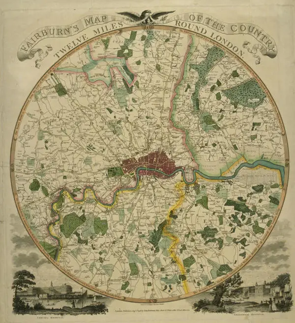
Some maps emphasised their usefulness for the tourist or day-tripper, for example, Cruchley’s map of 1833 includes information on fairs, market towns and market days and Watermen’s’ fares (LPA 330597) and the ‘Family Times’ map of 1846 provides information on the sights of London and places of entertainment (LPA 31078). But perhaps one of the most fun and decorative examples is the map by John Fairburn, first published 1798, depicting an area twelve miles round London and including engraved views of Chelsea Hospital and Greenwich Hospital; it was re-issued again in 1800 and finally in 1831 when Fairburn published the map printed on calico with the amended title, ‘The Travelling Handkerchief’ (for first edition see LPA 31055).
The Metropolitan Map series of environs maps has been catalogued under code SC/PM/EN* and can be accessed via the online LMA Collections Catalogue, There are also many other environ maps across our collections and many are available to view digitally on Collage: The London Picture Archive.