Image detectives - Hendon Way
Since March 2020, LMA staff, later joined by volunteers, have been working on a fascinating project: geotagging and improving the descriptions of nineteenth- and twentieth-century images of London streets and buildings, in order to make them more informative and research friendly. Originally created by the London County Council for administrative purposes, Series 01 comprises about 96,000 photographs, many of which document places that no longer exist, having been demolished, destroyed in wartime air raids, or redeveloped.
Fully digitised and available to view on the London Picture Archive, the images are excellent resources not only for the built environment of London, but also for social history. However, as they were created by council officers for office use, their original titles and descriptions are very brief, focusing primarily on addresses. As such, they are not particularly suitable for online research. In quite a few cases, the original descriptions are inaccurate or simply wrong, as mistakes have crept in along the way during the images’ long journey from an LCC officer’s desk to the LPA website. In such cases, researching the location shown in the image requires some detective skills, as Dorota Pomorska-Dawid and volunteer Paul Bolding showcase here with image 157975.
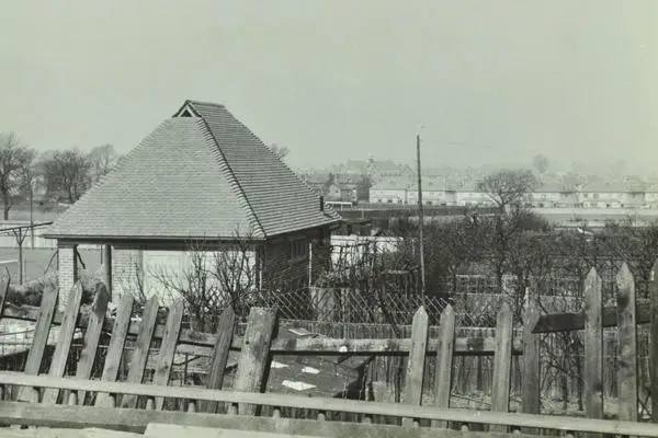
Image 157975
Image 157975 is an unassuming photograph from a Barnet box, which was researched and described by one of our volunteers, Paul Bolding. It was originally described as Hendon Way, Barnet: from Lyndale to Cricklewood Lane, and thus located somewhere within a 400-metre stretch of the road. A 1924 picture, it was one of a small series taken soon after the 1923 opening of Hendon Way in north London (note the punch holes on the side, which all the photos in the series share, having been bound together). Paul found the original description useful but wanted to pin it down, especially as Hendon Way itself did not seem to be featured in the image, so the original description could have been wrong. Our main research tools – Google Street View and OS maps – did not turn out to be very helpful; there was no sign of the pavilion visible in the foreground on either of them. It did not help that the photo dates from 1924, so too late for the building to appear on the 1893-95 OS map, and too early for it to still exist on the 1944-70 one, as Hendon Way had been significantly redeveloped by then. Paul did initially focus on a very similar pavilion a bit further along Hendon Way but it turned out to be a red herring. So, in his words:
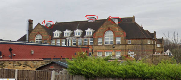
"My only hope was to zoom in on the background. There is a distinctive neo-Gothic building there with four towers and a roof turret, so I looked around on Google Street View but failed to find it. After trying a few other ideas, I went to the Britain from Above website to see if the area was covered, and it was pretty easy to spot the building. The distinctive oval street pattern of the Golders Green Estate nearby made it easy then to locate the building: a school. The towers and bell turret have since been truncated, sadly, which was why it didn’t stand out on Street View. That allowed me to get a reasonable fix on where the picture was taken from."
Paul Bolding
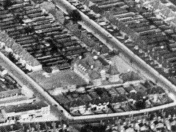
Britain from Above used by Paul is an invaluable research tool. Run jointly by Historic England, Historic Environment Scotland and The Royal Commission of the Ancient and Historical Monuments of Wales, the website contains 95,000 aerial photographs of Britain taken between 1919 and 1953, which are a part of the vast Aerofilms collection. As a result of Paul’s research, the description of Image 157975 could be changed to the following, much more informative one:
A view from Hendon Way, Hampstead, recently constructed in this picture, near the junction with Hocroft Avenue. A brick-built pavilion with a verandah and steeply pitched roof stands in the foreground facing a yard; at its backs are allotments. A broken fence crosses the picture in the foreground. The pavilion and allotments no longer exist, as the area along Hendon Way was later substantially redeveloped. In the distance are rows of semi-detached houses in Cricklewood Lane and on the skyline, the large Gothic building with a roof turret and four towers which is Childs Hill Primary School in Greenfield Gardens. It still exists, though the towers have been removed. This image was one of a series taken around the time of the opening of Hendon Way in north London. Opened in 1923, it was widened in 1962 and is now one of London's busiest thoroughfares.
If you would like to find out more about the LCC Series 01 Photo Project, or join the group of volunteers working on it and become an image detective yourself, please email us at LPA support