John Cary mapmaker and engraver
The Metropolitan Map collection at LMA is a major collection of maps which form part of the core collections at LMA. They are mainly printed and are an important source for documenting the history of London and its environs.
The aim of the Metropolitan Map project 2018-2020 has been to catalogue the maps in order to make them easily available to researchers. The project has allowed us to not only catalogue and make available for research many hundreds of maps, but it has also allowed us to look in more detail at the maps within our collections. Here project archivist Amy Proctor she explores the life and works of John Cary mapmaker and engraver (1755-1835).
John Cary was born in Wiltshire on 23 February 1755. In March 1770 he was apprenticed to the engraver William Palmer of New Street Square, London who was responsible for a wide range of engraved works at the end of the 1770s including a plan of the Cities of London and Westminster and Borough of Southwark which was published by William Faden in 1785 (London Picture Archive 31044).
Cary’s early works appear to focus on documenting the new canals but by 1783 he had established himself as a map seller and engraver at 188 Strand, moving some eight years later to 181 Strand. His output was most prolific, engraving and publishing a wide range of material such as road maps, town maps, itineraries, geological maps, atlases, globes and county maps. He was recognised for the quality of his engraving but also for being innovative (his 1794 ‘New Map of England and Wales’ was the first such atlas to adopt the meridian of Greenwich) and for taking great care over the accuracy of his works (his large scale map of Cardiganshire was awarded the Royal Society of Arts Gold medal in 1804) and this is an aspect of particular note in his London maps.
In the early 1800s there were few original maps of London published. Instead there was a prolific trade in re-issues of earlier maps with only slight amendments which often failed to truly reflect the rapid urban development happening across the capital. Cary was unusual in trying to incorporate changes with each new edition of his work.
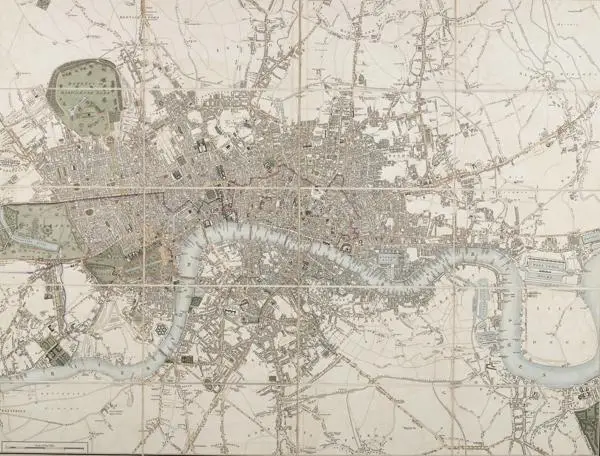
His earliest map of London was published in 1782, ‘London, Westminster and Southwark, accurately delineated from the latest surveys to which is now first added a correct list of upwards of 350 coach fares’ (third edition LPA 330466; sixth edition LPA 330469). The map was issued six times, the final edition issued 1787. That same year he published ‘Cary’s New and Accurate Plan’ (first edition SC/GL/PR/GP/LA/003/k1275992/A). At a scale of 6 ½ inches:1 mile there was enough space to produce an accurate and detailed map, divided into squares for reference, and accompanied with a list of upwards of 500 principal streets. It was published in the popular folding map format with slipcase and came to be one of the principal maps of London of the era. It was re-issued with regular amendments to reflect new developments such as the urbanisation of previously open spaced parts of the city like the area around St. George’s in the Field and the appearance of new bridges. These changes were relatively simple to incorporate but the various editions are also notable due to the care Cary took to incorporate changes within already built up areas (such as the opening of Regent Street) which made re-working the plates more challenging. The map was issued over twenty times, the final edition being published in 1825 (LMA holds many of the editions and some editions may be viewed on the London Picture Archive: two examples are seventh edition, 1800, LPA 330501; and nineteenth edition, 1824, LPA 330572).
In 1790 he published, ‘Cary’s New Pocket Plan of London’, a folding map on the slightly smaller scale of 4 inches:1 mile. This was a practical, detailed map, including a table of Hackney coach fares, it was re-issued with regularity and over 18 editions were published over forty years, the final edition was issued in 1836, the year after Cary’s death. London Picture Archive examples include the third edition, 1793, LPA 330480 and the fifth edition,1796, LPA 330326.
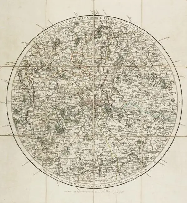
Cary also produced some environs maps. ‘A survey of the Country fifteen miles round London’ was first published in 1786 (SC/PM/EN/01/01/046); mindful of the need to be commercially successful the map was available either mounted together on rollers or bound into a book of 50 sheets with an index and showed country seats and the name of their possessor. A smaller scale map of the ‘Country 22 miles round’ was also published in 1786 (LPA 330468). In 1810 he published his ‘Environs of London’ map which was also known as ‘Cary’s New Itinerary’; this map remained in print over eleven editions until 1828.
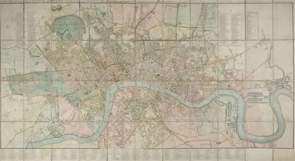
Cary is also notable for being a commercial success at a time when the costs of surveying, engraving and publishing cartographic material led some of his predecessors and contemporaries to bankruptcy. His career was not however wholly without adversity. In January 1820 he lost his premises and much of his stock in a fire which began in the neighbouring house. The Times reported that ‘the devouring element soon caught the dwelling of Mr Cary, the chartseller, and in a short time that building added to the melancholy grandeur of the spectacle.’ Cary moved his business to the premises of his sons at 86 St James Street with whom he jointly published several maps. The first map he published after the fire was issued in July 1820, ‘Cary’s New Plan of London and its Vicinity’, a map which was still in print in the 1860s (first edition LPA 330564).
Cary died in 1835 and he was buried at St Mary Abbots Kensington on the 22 August. His maps continued to be published by his sons until 1850 when the stock and plates were acquired by George Frederick Cruchley and thereafter in the 1870s passed to the firm of Gall and Inglis. There are many of Cary’s London maps in the collections at LMA.