London Central series of maps
The Project
The Metropolitan Map collection at London Metropolitan Archives (LMA) is a major collection of maps which form part of the core collections at LMA. They are mainly printed and are an important source for documenting the history of London and its environs. The aim of the project is to catalogue the maps in order to make them easily available to researchers.
Here project archivist Amy Proctor tells us about the London Central series mapping the development and expansion of London from pre-1666 through to the twentieth century.
London Central
The London Central series documents the development and expansion of London from pre-1666 through to the twentieth century.
The maps in this series focus on London as a whole, initially depicting London as the area within the medieval walls, and often including the area of Westminster and the narrow part of development in Southwark at the site around London Bridge; by the end of the series the London depicted has grown tremendously and most maps cover the whole of the County of London. There are over 700 maps in the series and they have been catalogued chronologically according to the date that they depict. For ease of navigation the series has been divided into sub-series, each including an example of a particularly notable map for the era.
London maps 1666 and earlier
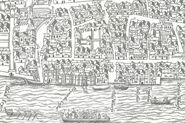
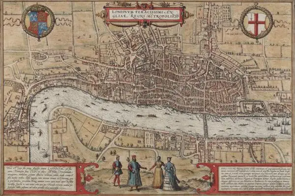
Prior to the Great Fire of London there are, perhaps surprisingly, remarkably few examples of maps of London and those that have survived generally provide a bird’s eye, pictorial view of London reflecting the cartographic practices of the time. Examples include the so-called ‘Agas’ map represented in this collection by George Vertue’s engraving of 1737 (SC/PM/LC/01/01/015) and the highly decorative map attributed to Braun and Hogenberg which provides a visual representation of London at the time of Shakespeare (SC/PM/LC/01/01/021-022). The Great Fire of London in 1666 prompted a need for the City authorities to have an accurate plan of London and marked a change in cartographic style with the highly decorative bird’s-eye view giving way to a more detailed and accurate two-dimensional map.
London 1666-1769
This sub-series includes several editions and facsimile reproductions of the map by John Ogilby and William Morgan (SC/PM/LC/01/03/004-011). Published first in 1676, this is notable for being the first detailed map of London, claiming to show every house and numerous boundaries, it provided a plain two-dimensional plan; later editions, published by Ogilby became more ornate including marginal decorations and bird’s-eye views of notable buildings. It was unrivalled in detail until the publication of John Rocque’s map of 1746 (SC/PM/LC/01/03/050-059).
The early 1700s saw a growth in the publishing of not only new and original maps but also re-editions; competition for sales led many maps to proclaim in their titles that they show new buildings and improvements (with some providing depictions of developments that had yet to take place!) In order to promote new sales, a new type of map, aimed at the tourist or visitor to London, began to be produced which contained additional information beyond a simple street plan, for example Henry Overton’s ‘New and Exact Plan’ of 1720 included a table of rates for Hackney coaches and watermen (SC/PM/LC/01/03/029).
London 1770-1859
This era covers two sub-series and includes examples of the map of Richard Horwood, following in the tradition of Ogilby and Morgan, Horwood aimed to produce a map of unrivalled detail showing every house. Though his ambition was not quite fulfilled, the map published in 32 sheets between 1792 and 1799 provides an exceptionally detailed representation of London (SC/PM/LC/01/04/031-037). It was re-issued by William Faden who extended Horwoods’ original work to include the area of the Isle of Dogs and the new docks to the east (SC/PM/LC/01/04/133-134). It is also in this period that Christopher Greenwood published his large scale map in 1827 (SC/PM/LC/01/05/031-038).
There are examples of some of the most re-published maps of the era including Edward Mogg’s ‘Entire New Plan’ published in 1804 (SC/PM/LC/01/04/065). Mogg re-published the map, with varying alterations and amendments, over 20 times the last being in 1828. John Cary’s , ‘New and Accurate Plan’ published in 1787 (SC/PM/LC/01/04/019) was similarly re-published multiple times and George Frederick Cruchley’s, ‘New Plan’ first printed in 1827 (for 1828 edition see SC/PM/LC/01/05/046) was still in publication in 1851, when it was amended to show the site of the Great Exhibition.
London 1860 onwards
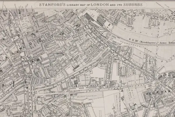
The major map in this sub series is arguably Edward Stanford’s, ‘Library Map of London’, published in 1862 (SC/PM/LC/01/06/016-020). The map provided the most up-to-date representation of London since Greenwood’s map of 1827; showing major changes such as the new canals and railway lines, roads, through-fares, the ever expanding dock networks and the increasing urbanisation of London in all directions swallowing up former rural area. This map was issued on multiple occasions with the final imprint being published in 1901, but its enduring importance lies in its use as a base map to plot the sites of services and facilities by bodies such as the Metropolitan Board of Works (established 1855) and the School Board of London (established 1870).
The London County Council (LCC, created 1888) published a number of maps including the 1901-1902 map ‘shewing the growth of London’ (SC/PM/LC/01/07/001-003) and the 1913 Municipal Map (SC/PM/LC/01/07/044-047), though these were not entirely new surveys, but were based on the work of the Ordnance Survey. Other examples of maps based on the Ordnance Survey are those published by Kelly’s Directories of which several are represented in the collection.
Detailed descriptions of the London Central Maps can be found on the LMA Collections Catalogue under reference SC/PM/LC/01 and the maps may be requested for consultation in the Archive Study Area at LMA.