Magnificent Maps of London exhibition
Some of the finest maps of London feature in our latest exhibition, which will reveal the history and development of the capital and provide a rare opportunity to see the first surviving map of the city.
Magnificent Maps of London brings together an extraordinary selection of maps drawn from our extensive collections. Visitors are able to immerse themselves in large scale prints of some of the best-known maps of the capital, experiencing the growth and development of the city from the late sixteenth century to the present day through the work of Georg Braun and Frans Hogenberg, John Rocque and Christopher and John Greenwood and many others.
Delving into thousands of London maps to present some of the most remarkable, the exhibition uncovers the pastures and fields lost under the urban sprawl of the city, the calamity of the Great Fire, and the experience of London's communities in the second half of the twentieth century. Early visitor guides feature, alongside tram routes, detailed insurance plans, local plans and thematic surveys, including poverty, pandemic and population studies.
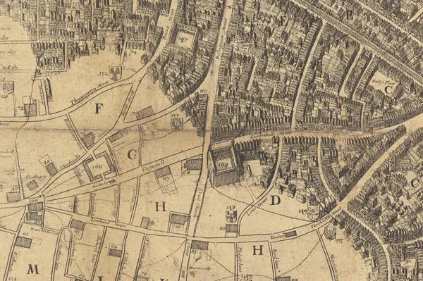
The maps on display include Civitas Londinium, which shows London in the 1570s. The first surviving map of London, this incredible ‘map view’ is one of only three known prints and goes on display at London Metropolitan Archives for the first time. The map has been painstakingly cleaned and prepared by the LMA conservation team using special techniques to remove centuries of surface dirt.
The only known copy of the first edition of John Leake’s Survey of the Ruins of London from 1667 is also on display for the first time. This view of the devastated post-fire city is intricately engraved by Wenceslaus Hollar, his charming ‘bird’s eye’ pictures of houses in the unscathed areas giving the feel of what was lost.
Maps created to study and understand the progress of typhoid, cholera and smallpox within Victorian London’s population are displayed together, revealing both the terrible loss and suffering inflicted on Londoners, and the development of knowledge required to overcome an epidemic.
In an age when drivers are directed to their destination by an app on their phone, John Ogilby’s Britannia Depicta from 1698 will certainly surprise. This large, heavy tome depicts the road from London to Holyhead in strip format, requiring travellers to turn page after page as their coach progressed.
Magnificent Maps of London runs until 29 March 2023 and admission is free. The exhibition is the culmination of a program of work to catalogue and share LMA’s historical map collections through the London Picture Archive website where thousands of historical maps of the capital are waiting to be explored.