C.H. Matthews - highlighting topography
As part of our ongoing upgrades to the London Picture Archive, we've created several new galleries of artists and topics which have perhaps been neglected in the past. In this gallery, we celebrate the work of Victorian Watercolourist C.H Matthews.
Topographical paintings
The watercolours of C H Matthews held at London Metropolitan Archives are largely within the Metropolitan Prints collection of the London County Council and some from the former Prints and Maps collection at Guildhall Library. There are other examples of his work held at the British Museum which are largely pen and ink drawings. There are possibly overlooked examples in some local archive collections too. They represent a window into an artist’s eye-view of London in the early to mid-nineteenth century.
These works form an important part of our understanding of the landscape of London and its people: whether real or through an imagined and idealised nostalgia. A visual mapping of this landscape takes place within topographical works which also hold an aesthetic value.
Definition of Topography
The Oxford English Dictionary defines topography as ‘the science or practice of describing a particular place, city, town, manor, parish, or tract of land; the accurate and detailed delineation and description of any locality.’
Topographical works are perhaps a neglected resource where cultural value is to be found, infusing a sense of identity in a place at a particular time.
Engravings have been hidden away in illustrated books and are historically at the mercy of the classification placed upon them by the library or institution. What constitutes topographical works are forever changing, frequently viewed as a pictorial record rather than art. However, with vast numbers of such works in existence there is scope for them to be classified as a major part of the British canon of landscape art rather than purely an antiquarian curiosity. We might think about who it was intended for such as in a publication or for personal record and distribution to enthusiastic collectors.
There is a certain charm to be found in the work of a local artist who knew the area and its people well. But how reliable are these works as a form of accurate documentation? Supplementary evidence can often help supply an anchor for these artworks.
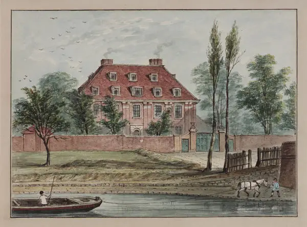
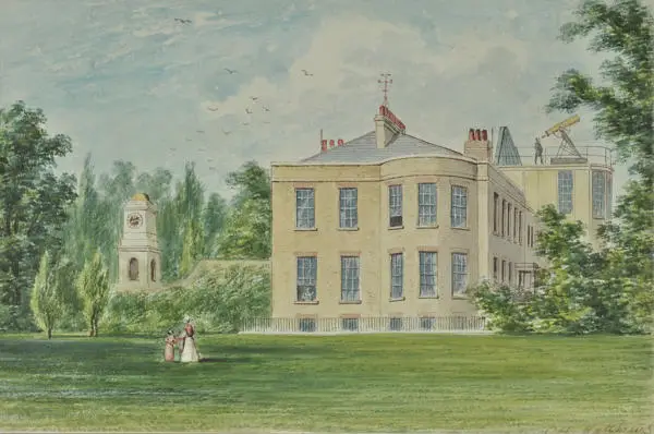
Highbury House, Highbury Terrace
Alexander Aubert (1730-1805) was an amateur astronomer, we suspect that he is the man using a telescope on the roof of Highbury House (see also 303219 for a portrait of him). He purchased the house at Highbury in 1788 (built by John Dawes in 1781). An observatory was installed with his friend the engineer, John Smeaton (291222). The clock from St Peter-le-Poer, formerly of Old Broad Street, was erected in the grounds here in the eighteenth century. Aubert had a connection to this church as he was baptised there on 11 May 1730.
Nearby Aubert Park and Aubert Road take his name. [London Picture Archive 303212]
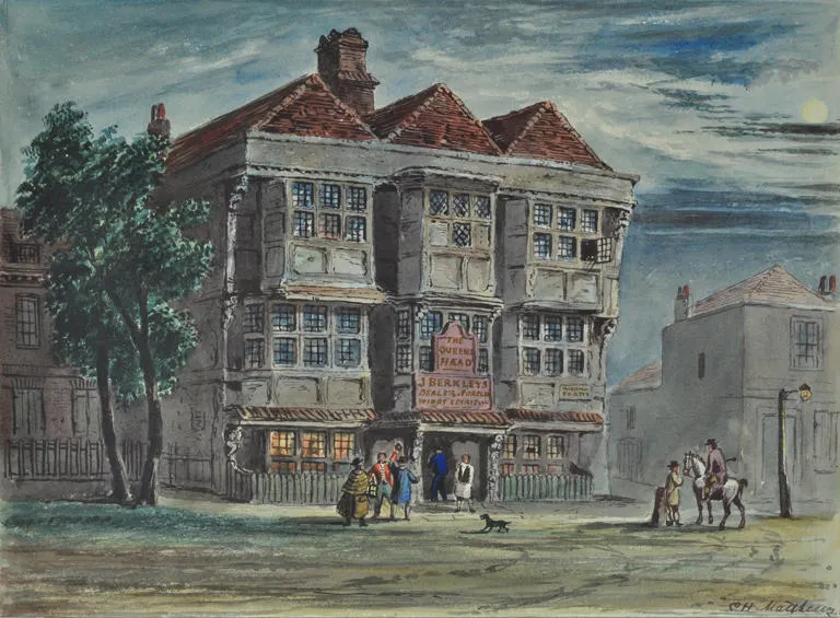
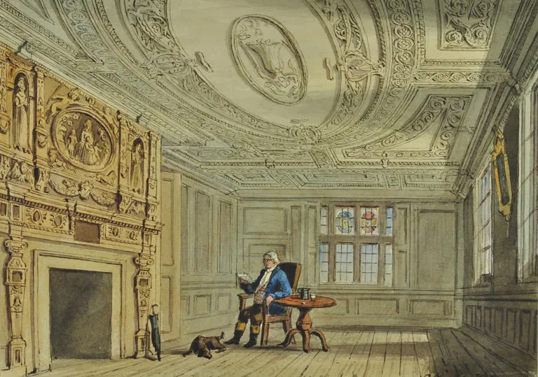
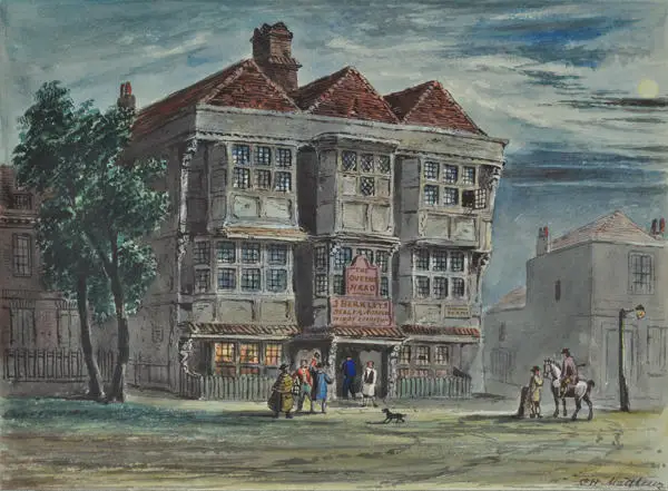
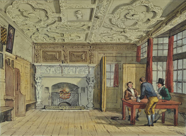
Queen's Head, Essex Road, Islington (exterior and interior)
The Queen’s Head public house on Lower Street (which later became Essex Road) is still there today as the Old Queen’s Head. Some of the original features are extant in this Grade II Listed Building. The seventeenth century exterior has altered since Matthews depiction whilst some interior elements have been preserved. It was redeveloped in 1830 and 1900 so it is quite possible he was re-imagining this exterior from earlier prints. [London Picture Archive 303610 and 303611]
"A ceiling of early C17 modelled plasterwork with bands of scrolling floral ornament forming panels to enclose emblems, some in cartouches survives above bar area of the public bar. In the north-west corner the wall is panelled to either side of an early C17 chimneypiece of stone and wood. The surround to the hearth is of stone, with term figures to either side supporting an entablature with narrative, perhaps mythological, scenes carved in two panels under a frieze of strapwork. Above, the chimneypiece continues in wood with three term figures, decorative panels between, decorative frieze and bracketed cornice."
Historic England listing information
Pied Bull, Upper Street, Islington
At no.98 Upper Street, on the road parallel to the Queen’s Head, was the Pied Bull. It was formerly the residence of Sir Walter Raleigh before it evolved into a pub. This area still had Tudor houses until around the mid-nineteenth century. Matthews, it would seem, sought to document the changing landscape and record places that were at risk of disappearing. On the site today is The Bull at no.100. [London Picture Archive 303752]

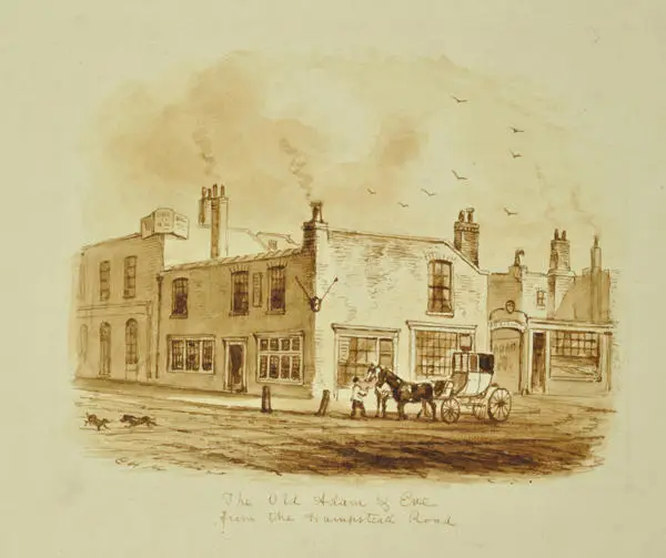
The Adam and Eve Public House, Tottenham Court Road
Matthews depicts a popular entertainment venue near the Tottenham Court Road area on Hampstead Road at a time when this area was on the edge of rural land. Its gardens were a site for tea-drinking parties and now where the Euston Tower on Euston Road stands. The original inn dates to c.1718 and its sign can be seen in William Hogarth’s painting “March to Finchley”. [London Picture Archive 305467]
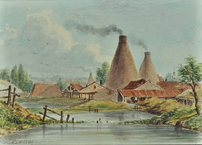
Tile and Brick Kilns, location unknown
The site of these kilns could be the tile kilns just north of Regents Canal which would be used for transportation. It might be the dome of St Paul’s that is just visible on the horizon to the left and St Pancras old church to the right. But there were many kilns dotted about the landscape which were first used for brick burning and tile making, for example Maiden Lane, now York Way, had tilemaking firms including those at Belle Isle. [London Picture Archive 303360]

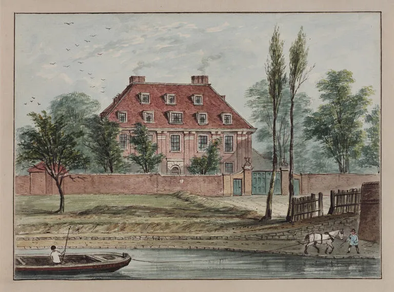
Baumes House, Hackney
George Whitmore, Lord Mayor of the City of London in 1631 and master of the Haberdashers Company, resided at Baumes House which had been built in the sixteenth century. He owned substantial stock in the East India Company and rebuilt the house in Italianate style living here until his death in 1654. Balmes Road is on the site today in De Beauvoir Square behind the Regents Canal which is in the foreground here. It is likely to have been named after Lord Mayor, Adam Bamme’s estate here in c.1390.
In the late eighteenth century, it was a lunatic asylum and had been demolished by 1852. Matthews was possibly living nearby in the 1850s and this subject may have sparked his interest. [London Picture Archive 7505]