Borough Maps
The project
The Metropolitan Map collection at London Metropolitan Archives (LMA) is a major collection of maps which form part of the core collections at LMA, they are mainly printed and are an important source for documenting the history of London and its environs. The aim of the project is to catalogue the maps in order to make them easily available to researchers. Here project archivist Amy Proctor takes a closer look at the London Borough maps.
The Borough Maps
The first series of maps to become available for researchers are the Borough Maps (SC/PM/MB/01) which cover either the City of London or one of the 28 Metropolitan Boroughs which functioned under the LCC. These consist of nearly 1,300 maps, often very detailed, giving street names (and sometimes property numbers) as well as the site of new or proposed developments.
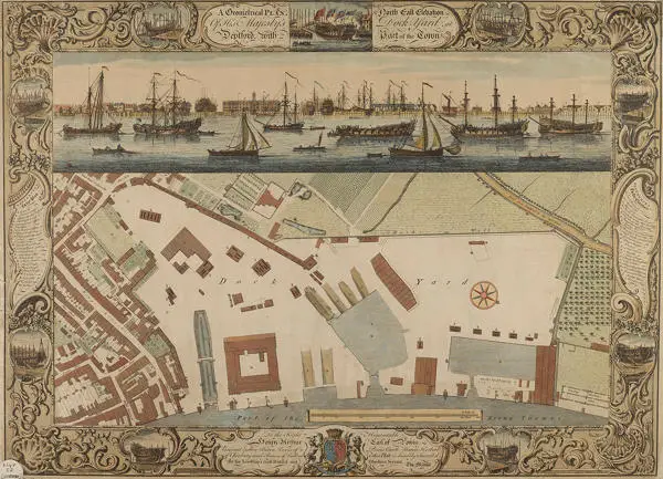
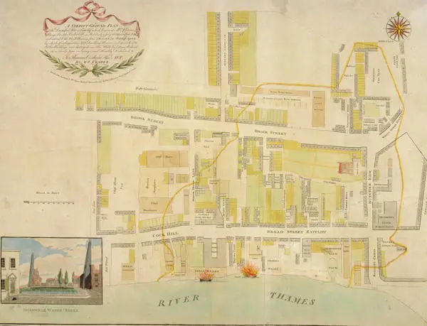
Amongst the highlights of this series (of which there are many) are the City of London Ward Maps of Benjamin Cole (1725–1813), the third generation of a family of engravers, publishers, mathematical and optical instrument-makers, whose maps of the administrative areas known as Wards in the City capture not only the street lay-out but also pictorially represent notable buildings and include exterior illustrations (for example, SC/PM/MB/01/01/066 for Cheap Ward). Other highlights include a detailed plan of the Dock Yard at Deptford and the surrounding area by Thomas Milton which is decorated with a magnificently engraved view of the River Thames showing vessels and river traffic (SC/PM/MB/01/07/009); and maps which document particular events such as that created by the artist William Frazer depicting the area in Ratcliffe devastated by fire in 1794 (SC/PM/MB/01/25/032).
The maps are being catalogued in chronological order as defined by the date that the map depicts. By viewing the maps of a particular area in this order the collection provides a wonderful visual resource of the often rapid changing nature of some areas, one notable example being the development of the area around St. George’s Circus, Southwark. An area which was transformed from rural and marshy countryside into a major thoroughfare linking the City, via Blackfriars Bridge, with the Elephant and Castle and beyond.
Continue your research
Detailed descriptions of the Borough Maps can be found on the LMA Collections catalogue under reference SC/PM/MB/01 and may be requested for consultation in the Archive Study Area at LMA.